Styrian Iron Trail
The new long-distance hiking trail "Styrian Iron Trail" leads through the Region Erzberg-Leoben in 10 days, covering a total of 200 kilometers and 9,000 altimeters.
News
- ATTENTION: The 3rd section is temporarly closed due to work following a windthrow. A bypass route can be found on Outdoor-Active.
- Well-equipped with new merchandise items - water bottle, snack box and T-shirt in Styrian Iron Trail design
- 26 certified Styrian Iron Trail businesses - which means they are ideally located on the route with perfect facilities, service and gastronomy
- Special hiking offers (trail tryouts, special offering of luggage transport etc.) Gasthof Eberhard, more businesses to follow
- Collected all the stamps? - Get a prize at the Erzberg Leoben Tourist Office + a chance to win the main prize
- Camping along the route is not permitted
STYRIAN IRON TRAIL Video

The long-distance hiking trail through Styria
„STYRIAN IRON TRAIL“
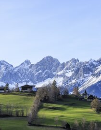
The "Styrian Iron Trail" allows hikers to explore the Region Erzberg-Leoben in 10 sections. The trail leads 200 kilometers and 9000 meters of altitude through the 16 municipalities of the adventure and sports region. The trail combines scenic beauty with the historical apsects of mining in the region.
The Styrian Iron Trail - an overview
Duration: 10 days - 66 hours walking time
Difficulty level: varies from easy to difficult
The difficulty can be easily divided into 3 sections, so there is something for every fitness level:
- The first three sections from St. Michael to Wald am Schoberpaß are considered a leisurely hike.
- From the fourth section onwards, more challenging mountain trails await the long-distance hiker.
- The last segments offer a beautiful finish via Trofaiach, the Himberger Eck and the Mugel to Leoben.
Season: All sections are easily accessible from May to October, although sections 6 and 7 (Sonnschienhütte closed) must be avoided from September 15 to October 15 due to the hunting ban.
Perfectly equipped
With the merchandise products you are always well equipped - snack box, drinking bottle and T-shirt in the Styrian Iron Trail design. These are direchtly available at the Erzberg Leoben Tourist Office.
Arrival via public transportation
The starting point in St. Michael can be reached comfortably and climate-friendly by train.
Almost all stops are easily accessible by public transport. (Exception: Sonnschien) From the final stop in Leoben, it's a comfortable journey home by public transportation.
In the 4 municipalities of Kammern, Mautern, Kalwang and Wald am Schoberpass, there is also the option of using the Postbus shuttle (Styrian Iron Trail fare), with over 115 bus stops, beyond the usual post office stops and without a fixed timetable, to reach your destination for just € 0.50. Selected destinations outside the service area can also be reached from St Michael via Traboch to Trofaiach.
► Download the Postbus Shuttle app on Google Play and in the App Store.
The Postbus shuttle runs from Monday to Friday from 07.00 a.m. to 09.00 p.m., Saturday 09.00 a.m. - 02.00 p.m.
Arrival by car
Coming from Graz or Liezen via the A9 to the St. Michael junction, exit St. Michael, continue via the B113 to the train station.
Coming from Vienna via the S6 or from Knittelfeld via the S36 to the St. Michael junction, exit St. Michael, continue via the B113 to the train station.
There are several free parking spaces at the train station in St. Michael in Upper Styria.


„The most important piece of luggage is and remains a cheerful heart.“
STYRIAN IRON TRAIL
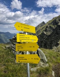
MARKING AND SIGNPOSTING SYSTEM
Marking and signposting system
Special attention should be paid to the marking and signposting system of the "Styrian Iron Trail". In general, red-white-red markings are used, but the main intersections are marked with direction arrows (orange signs with logo). Red-white-red stickers with the logo have also been affixed in the villages. Standardized information boards have been installed in the villages to give hikers a good overview of the entire route.
How is the logo put together?
The logo is a direct reference to the trail: the outer line shows the entire course of the trail; the three lines stand for the steps of the Erzberg and the upswing of the region. The orange color symbolizes the power of the glowing iron. The clear visibility in the terrain also contributed significantly to the decision. This tourism project literally runs as an "orange thread" through the municipalities and connects them within the new touristic Erzberg Leoben experience region.
„Styrian Iron Trail“ Facts
- Starting point: St. Michael (reachable via train)
- End point: Leoben (reachable via train)
- Distance: 200 KM
- Segments: 10


The Styrian iron trail "hiking warm-up" sections 1-3
The first 3 sections of the long-distance hiking trail "styrian iron trail" in Styria are perfect as a "hiking warm-up". The trail leads from St. Michael via Traboch to Mautern and on to Wald am Schoberpaß , allowing you to get to know the hiking potential of the Liesingtal .
Highlights along the way:
Lake Traboch, St. Ulrich Church in Seiz, Marterlweg, Rittersteig, Mellingalm.
Hiking data:
Day 1: St. Michael to Seiz (21,2 Kilometer / 520 Hm)
Day 2: Seiz to Mautern (13,3 Kilometer / 750 Hm)
Day 3: Mautern to Wald am Schoberpaß (23,3 Kilometer / 1000 Hm)
ATTENTION: The 3rd section is temporarly closed due to work following a windthrow. A bypass route can be found on Outdoor-Active
The Styrian Iron Trail - mountain sections
From the 4th section onwards, long-distance hikers can expect more challenging mountain trails (Radmer, Eisenerz, Sonnschienhütte, Tragöß to Vordernberg). The route takes 4 days from Wald am Schoberpaß to Vordernberg.
Highlights along the way:
Antonicross, Nordic Training Center of ÖSV, Schichtturm, Lake Leopoldsteiner, Green Lake
Day 4: Wald am Schoberpaß to Radmer an der Stube (21 Kilometer / 1320 Hm)
Day 5: Radmer an der Stube to Eisenerz (16,2 Kilometer / 780 Hm)
Day 6: Eisenerz to Sonnschienalm (21 Kilometer / 1300 Hm)
Day 7: Sonnschienalm to Vordernberg (25,3 Kilometer / 1000 Hm)


The STYRIAN IRON TRAIL - Finisher
When the "Styrian Iron Trails" comes to an end, the hike leads from Vordernberg to Leoben in 3 days. The last sections offer a beautiful finish via Trofaiach, the Himberger Eck, the local mountain for Leobeners, the Mugel, and all the way to Leoben.
Highlights along the way:
Radwerk IV, pilgrimage church Maria Freienstein, Barbara Chapel, Maßencastle
Day 8: Vordernberg to St. Peter-Freienstein (20,2 Kilometer / 600 Hm)
Day 9: St. Peter-Freienstein to Niklasdorf (24,2 Kilometer / 880 Hm)
Day 10: Niklasdorf to Leoben (19,4 Kilometer / 1180 Hm)


Hiking together
Initiators
Weges
WEGES is the full-service hiking agency in Styria - the green heart of Austria.
With Weges' founders, Silvia Sarcletti and Elisabeth Zienitzer, the "Styrian Iron Trail" can also be hiked as a guided tour. You can find more detailed information here.